Various Counties, North Carolina
The Seam Advancement Study
Stitching the Region Together
status
Completed 2024
client
Charlotte Regional Transportation Planning Organization
expertise
Public Infrastructure, Public Realm + Open Space
services
Master Planning Landscape Architecture Civil Engineering


Navigating Complexities of Multi-Jurisdictional Trail Planning
The Seam is poised to be a catalyst for regional connectivity—a micro-mobility "super-highway" that weaves together former textile mill communities, from urban centers to rural edges.
The Seam is one of the most exciting near-term opportunities to develop a multi-jurisdictional, multimodal corridor in the greater Charlotte region. The 72-mile active transportation corridor parallels the future CATS Red Line commuter rail and connects historic downtowns, including Pineville, Charlotte, Huntersville, Cornelius, Davidson, Mooresville, Troutman, and Statesville. In 2022, LandDesign embarked on a collaborative planning process with the Charlotte Regional Transportation Planning Organization (CRTPO) and a multi-agency steering committee to expand the alignment and determine strategies for the next phases of planning, public engagement, and funding.
The ambitious planning process was put into motion with the goal to optimize the regional bicycle, pedestrian, and transit network; prioritize equitable investment across communities; and celebrate the region’s rich history and cultural diversity. The plan identifies a single preferred alignment and context-sensitive trail typologies to ensure a seamless experience while traversing different land use patterns and street environments. The project was championed by a multi-disciplinary design team led by LandDesign, who collaborated closely with CRTPO, the steering committee, and local trail advocates to realize the plan. When constructed, The Seam will stitch together eight historic downtowns, from rural to urban, and transform the transportation, cultural, and recreational opportunities to create local, regional, and national impact.

The Seam rekindles a long-standing vision to create a continuous north-south trail corridor that links communities through coordinated planning and investment in active transportation. The plan builds on the Mooresville to Charlotte Trail Plan (MCT) completed in 2013 that establishes a framework for a 30-mile trail from Mooresville to Uptown Charlotte and follows the Red Line commuter rail alignment. While the intent remains aspirational, the goal for this new process was to produce an implementable plan for The Seam that communities could champion with confidence.
The Seam Advancement Study extends the original alignment to include more communities, which meant the corridor would pass through a variety of settings. From rural towns and historic main streets to suburban centers and urban districts, each community offers unique opportunities for how people experience The Seam. Recognizing this diversity, we began our due diligence by understanding how each jurisdiction was thinking about mobility, active transportation, and greenway connectivity. By reviewing changes in land use, development, and local planning efforts, we ensured the plan aligned with community goals while maintaining regional vision.
Where Every Mile Tells a Different Story
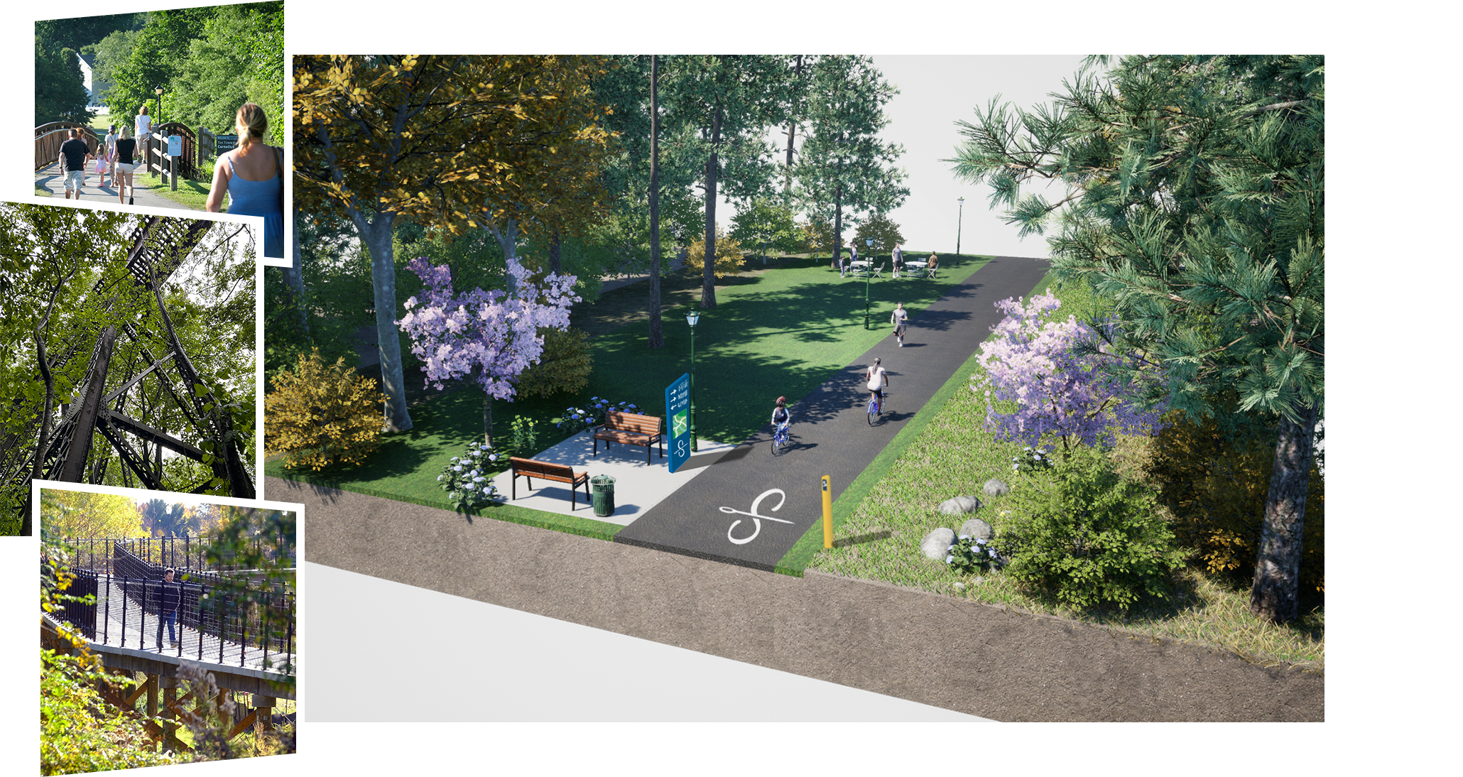
A key objective of The Seam is to offer a range of experiences while remaining cohesive across jurisdictions. We developed a framework of trail typologies–naturalized corridors, commercial thoroughfares, parkland and campus environments, and historic districts–to define how the trail adapts to its surroundings while maintaining a consistent user experience. Together, they ensure the corridor transitions seamlessly between settings, celebrating the region’s varied landscapes, economies, and cultural heritage along the way.


Spanning 72 miles and eight communities, The Seam required a level of coordination that few planning projects demand. The team understood that success depended on establishing a shared vision to unite jurisdictions with different needs, priorities, and resources. Some saw the trail as a centerpiece of growth and identity, while others envisioned it as a quiet connector woven into existing neighborhoods. Striking the right balance between local context and regional continuity became one of the project’s most complex challenges.
To strengthen trust and collaboration, LandDesign hosted a two-day visioning workshop and a series of field sessions that brought together municipal leaders, agencies, and advocates from communities across the corridor. We paired neighboring communities to discuss their connections, identify gaps, and reinforce collaboration across jurisdictional lines. This ensured that, whether in Statesville or Charlotte, the corridor would remain a consistent experience and unified identity.
Data-Driven Decision Making
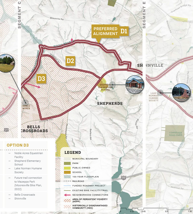
Using a data-based scoring process, the team evaluated multiple alternatives against more than 20 criteria to identify the alignment that best met the needs of most communities. The criteria reflected ideal trail conditions including separation from traffic; overall character and comfort; access to neighborhoods and disadvantaged communities; and ease of implementation. The resulting alignment balances trail experience, local constraints, and long-term feasibility to create a framework for informed decision-making and implementation advocacy.

Connecting the Corridor, One Segment at a Time
The Seam can function as one connected corridor, even while built incrementally. The plan includes a series of graphics and data-driven tools that provide tangible information for leaders to communicate the value of The Seam and continue to advocate for funding.


Physical
Leveraging GIS modeling and field analysis to establish a data rich framework for the 72-mile corridor, guiding an alignment that integrates naturally with its surroundings and existing infrastructure
Functional
Defining trail typologies and characteristics to create a recognizable and seamless corridor despite traversing varying land use patterns, local contexts, and street environments
Social
Celebrating the region’s textile mill heritage that fueled early growth by highlighting communities along the corridor that have evolved from industrial roots into vibrant neighborhoods with shared history
From Neighborhood Path to National Model
The Seam is poised to transform transportation, cultural, and recreational opportunities to create local, regional, and national impact.
-
8
historic downtowns and key institutions stitched together
-
10+
regional greenway systems connected
-
100,000+
residents will be within walking distance (0.5 miles)
-
425,000+
jobs will be within cycling distance (2 miles)
-
40%
of the corridor falls within priority areas, such as historically disadvantaged communities
-
42.7
miles of greenway separated from vehicular traffic